Monday, November 18, 2013

IAT - 11/17/2013 - End of Montrose Segment to Start of Cross Plains Segment

With tornadoes hitting Illinois we bailed north for the day to get some miles in.  It was nice and warm, but I started hiking in a thunder storm.  It rained really hard for the first couple miles then turned to a light drizzle before tapering off to nothing for most of the day.  Right as I was about 2 miles from the end of the day it started raining again really hard and with the wind blowing hard I was soaked again.  But in between the rain it was actually a good day for a hike.  Hit the 300 mile mark so that was a nice milestone.  Hopefully next year I can pickup the pace a little, but there are just so many other trails to hike!  With the weather I didn't even think about bringing my camera so just some cell phone pictures below.  Even on a raining day in late fall there were still some nice sights.

Start of Verona Segment.

Cool small cascade along the trail.

Just on the other side of the cascade a nice small lake.

This is the DCA?!  Pretty small area and a regular park about 100 yards away...

Nice view along the Verona segment.

End of the Verona Segment.

Start of the Madison Segment.  Clouds were not looking good, but never got too bad.

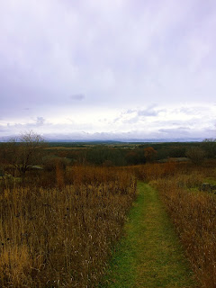
View along the Valley View segment.

View along the Valley View segment.

View along the Valley View segment.

Mile 300 (or there about).  Pretty much sums up a lot of the IAT - roads and fields.

This is actually an old drinking fountain.

Shoveler Sink.

Cool mailbox along a connecting route.

IAT Interpretive Site.

Monday, October 28, 2013

IAT - 10-25-13 to 10-26-13 - New Hope Segment up to Plover River Segment

For this trip I hooked up with some fellow hikers that are also hiking the IAT.  We started at the Iola Winter Sports Club and hiked north.  The first day started pretty good with about 5 miles of actual trail, but after that we were out of the woods and pounding the pavement for 20 miles.  There were some long straight road stretches that were less than thrilling so I was very glad to have the company to keep things interesting.  The weather was nice and cool, but overcast for most of the day so didn't take too many pictures since the nice fall colors were mostly grayed out.

Iola Winter Sports Club ski jump.
Boardwalk along the trail.
There were a bunch of these cool sculptures along the trail.
Another little guy hanging from a tree.

A lake that was just off the trail.
Some trees along the trail.
Good view along a connecting route.
Cool looking barn.
Some cows that were very interested in us.
Kassie always making friends.
A TINY snake along the road.
The next day started with a nice sunrise and a (relatively) short 7 mile road walk.  From there the trail follows a bike path for a few miles and then we were finally back into the woods!  It was very nice to back in the woods and off of streets or flat bike paths.  From there the rest of the trip was much more enjoyable.  There were a few short road walks mixed between the woods, but overall we were in the woods the rest of the day.  The woods were very peaceful and we didn't see another person till we reached the Eau Claire Dells area.  The trail there follows the Eau Claire River with some nice views along the way.  We crossed the river twice on a bridge and then a dam and there were lots of cool rocks along the way.  At the end of the segment there is another 3 and a half mile road stretch that we knocked out as well so that we could all start at the Plover River Segment next time around instead of starting with a road walk.  All in all it was a nice couple days and got some good miles in.

Sunrise day 2.

Panorama of the sunrise on day 2.

Some kittens at a house we passed by.

(The other) Pike Lake.

The Mountain Bay State Trail.

Hill leading up to Klaver Kame.  This picture does not do the hill justice.

Old tractor along the trail.

Wouldn't want hikers to ruin all that beer drinking and killing stuff.

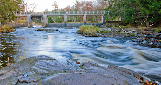
Small waterfalls along the Eau Claire River

The Eau Claire River.

View of the river along the trail.

View of the river along the trail.

Bridge crossing over the river.
Sean enjoying the view (and waiting to take a picture).
View from on the bridge.
View of the river along the trail.

Got to find out the name of this thing.  Very cool rock formation in the river.

Old bridge over the Eau Claire River.
Dam going over the river.
View from on top of the dam.
End of the Eau Claire Dells Segment.

Barn near the end of the Eau Claire Dells Segment near sunset.

Start of the Plover River Segment.


IAT - 10-19-13 - Hartland Segment to Delafield Segment

Since my trip the previous weekend got cut short I had an 8 mile gap to fill.  With such a short day I decided to get up early and enjoy the sunrise from Lapham Peak's observation tower.  I was the only up there on a nice 28 degree morning and took lots of pictures - some are below.  After that I drove over to the end of the Lapham segment where I had previously stopped and rode my bike back to Nixon park in the Hartland segment.  From there I hiked back to the car.  Because it was such a short stretch I ran most of the way and didn't carry my camera so no pictures of that route other then boring cell phone pictures I took of signs.  There wasn't much actual trail in the woods to this day.  It was a lot of road trail and paved bike paths so the running worked out good.  Made it back in a little over a hour, picked up my bike, and was on my way home after a short day.

View looking west.

View looking east.

View looking west.

View looking north.

View looking east.

View looking north-west.

View looking north.

View looking east.

Panorama from NW to SW.

Panorama looking north.

Panorama from NW to SW.